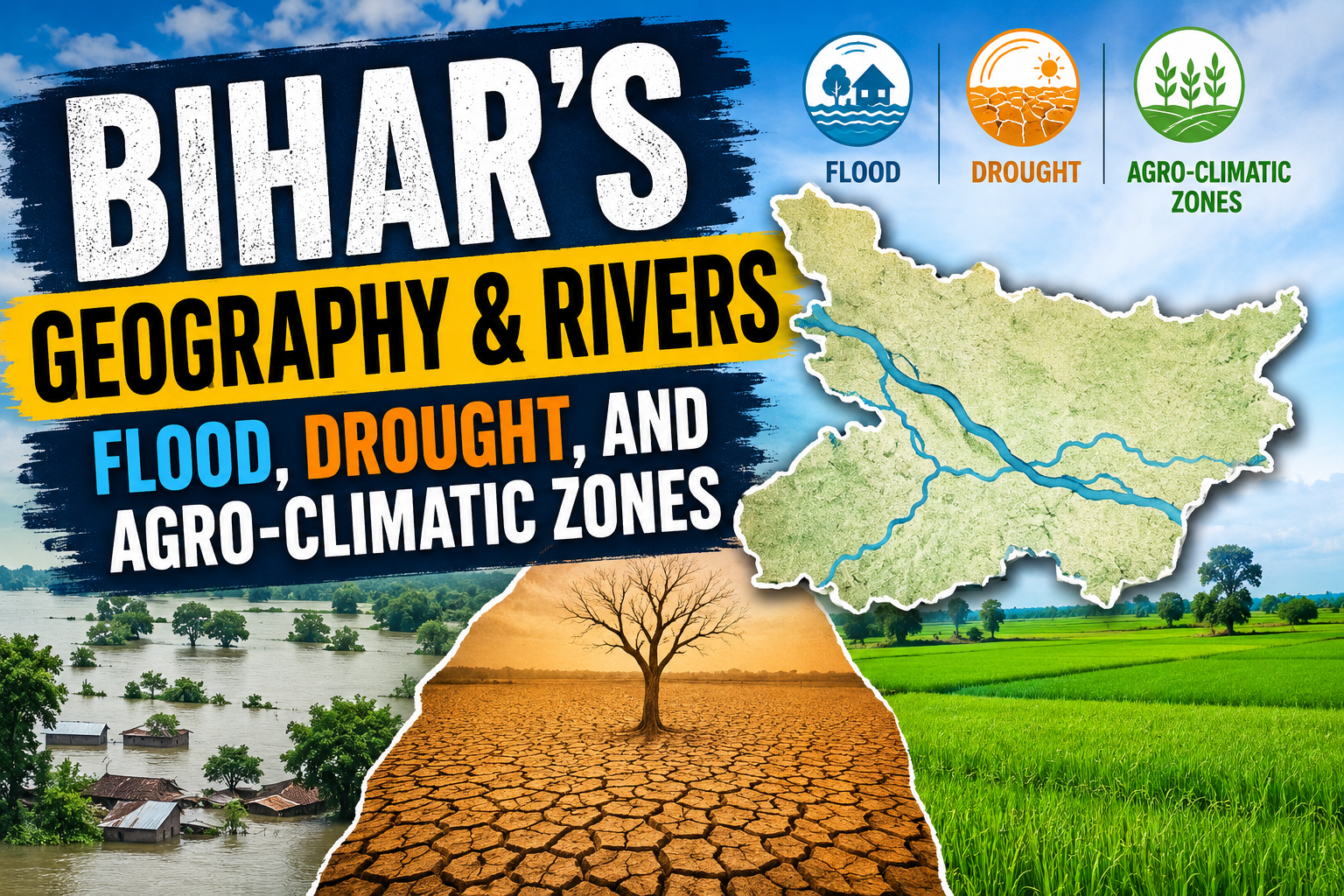
Bihar’s Geography & Rivers: Flood, Drought, and Agro-Climatic Zones
“The prosperity of a region begins with the understanding of its land and water.” Bihar’s geography proves this very clearly. The state’s powerful river systems, flood-prone plains, drought-prone southern tracts, and distinct agro-climatic zones shape its agriculture, settlement patterns, economy, and overall disaster vulnerability.
Bihar is often described through its rivers first and its farms second, because the two are inseparable. The Ganga, Kosi, Gandak, Bagmati, Son, and Punpun do not just pass through the state; they actively define how Bihar lives, grows, floods, and recovers.
Geographical Overview at a Glance
| Geographical Feature | Impact / Details |
|---|---|
| Lifeline River | The Ganga (Flows across the middle of the state) |
| North Bihar Threat | Devastating, recurring floods (The Kosi is known as the “Sorrow of Bihar”) |
| South Bihar Challenge | Moisture shortage, irregular rainfall, and local drought conditions |
| Agro-Climatic Zones | Divided into 3 distinct zones based on soil and rainfall |
Rivers that Shape Bihar
Bihar is overwhelmingly a river-dominated state. The mighty Ganga flows directly across the middle and acts as the state’s main lifeline, while several tributaries from Nepal and the Chotanagpur plateau feed into it. Monitored closely by the Water Resources Department, this immense water volume creates one of the most fertile, yet most volatile, landscapes in India.
The northern plain is especially vulnerable because many rivers descending from the Himalayas carry heavy silt, change course often, and overflow drastically during monsoon months. Rivers like the Kosi, Gandak, Bagmati, and Kamla are infamous for their unpredictable nature. The Kosi is often called the “Sorrow of Bihar” because of its devastating floods and frequent, destructive channel shifts.
At the same time, southern Bihar has a completely different water profile. Rivers like the Son, Punpun, and Falgu generally cause fewer widespread floods than the northern rivers, but many southern areas still face chronic water stress, irregular rainfall, and local drought-like conditions.
“Rivers are the arteries of civilization.” In Bihar, they are also the primary source of both prosperity and deep anxiety.
The Dual Challenge: North Bihar Floods vs. South Bihar Drought Stress
North Bihar Floods
North Bihar is officially one of the most flood-prone regions in India. Heavy rainfall in the Himalayas, rapid snowmelt, immense sediment load, and weak embankments all contribute to recurring disasters. The rivers here often spread over large areas during the monsoon, damaging crops, homes, roads, and crucial village connectivity.
Managed at the state level by the Disaster Management Department, floods are not just a natural event in Bihar; they are a seasonal social crisis. Every year, they severely affect:
- Agriculture and standing crops
- Transport and market roads
- Public health and sanitation
- Education and schooling infrastructure
- Overall rural livelihoods
A farmer in the north may see his standing paddy crop destroyed within hours. A school route may be cut off by rising water, and a market road may disappear entirely. This is exactly why flood management remains one of Bihar’s biggest developmental challenges.
South Bihar Drought Stress
Conversely, South Bihar faces a very different problem. It is not always about too much water; often, it is about not having enough water at the right time. Rainfall irregularity, specific soil differences, and a heavy dependence on seasonal rivers create acute drought stress in several areas.
The contrast between the two regions is striking. North Bihar struggles with excess floods, while South Bihar frequently struggles with moisture shortage. This creates a complex dual challenge for agriculture policy. One part of the state desperately needs drainage and flood control, while the other urgently requires irrigation, water conservation, and drought preparedness. Bihar’s geography is a classic, textbook example of severe environmental imbalance within a single administrative unit.
Agro-Climatic Zones of Bihar
As documented by the Ministry of Agriculture, Bihar is divided into three distinct agro-climatic zones, with each zone possessing its own unique soil type, rainfall pattern, and cropping suitability. This division is vital for agricultural planning because it links geography directly with farm output.
Zone 1: North-West Alluvial Plain
This zone includes districts in north-western Bihar and is characterized by fertile alluvial soil, high water availability in many areas, and strong agricultural potential. Crops like paddy, wheat, maize, sugarcane, and pulses are commonly grown here.
Zone 2: North-East Alluvial Plain
This zone is significantly more flood-prone and receives heavy rainfall. While it is rich in alluvial deposits, it also suffers from severe waterlogging and river overflow. Paddy, jute, maize, and pulses are the most important crops in this belt.
Zone 3: South Bihar Alluvial Plain
This southern zone generally features slightly different soil conditions and is much more prone to moisture stress and seasonal dryness in some parts. Wheat, paddy, pulses, oilseeds, and vegetables are important here, primarily relying on irrigated farming in suitable areas.
“If agriculture fails, the whole economy trembles.” Bihar’s distinct agro-climatic zones explain exactly why agricultural planning must be heavily region-specific.
Soil and Crop Relation
Bihar’s soil pattern is mostly alluvial, but it is not identical across the state. North Bihar soils are generally newer, highly fertile, and heavily river-deposited, but are also far more flood-affected. South Bihar soils are often slightly older and may require significantly better irrigation management in specific pockets.
This dynamic matters because crop choice depends heavily on soil and water availability. A crop that performs exceptionally well in a floodplain may struggle in a dry or semi-dry zone. That is why crop planning in Bihar must be scientifically aligned with local conditions rather than being treated as one uniform system.
For example:
- Paddy suits areas with more water.
- Wheat grows well where winter moisture and controlled irrigation are available.
- Maize performs strongly across several different zones.
- Sugarcane needs highly reliable water access and deep soil fertility.
- Pulses and oilseeds are highly useful where overall water availability is lower.
River Systems and Agriculture
The river system is the undeniable backbone of Bihar’s agriculture. Rivers actively deposit fertile silt, recharge critical groundwater, and support vast irrigation networks. However, when they overflow or change course, they also destroy fields and entire settlements.
This paradox is why Bihar’s agriculture remains both highly productive and incredibly vulnerable. The same river that nourishes crops in one season can flood them in another. The state’s farmers, therefore, live with constant uncertainty. Water is a blessing, but unmanaged water rapidly becomes a threat.
The right long-term response is not only building embankments. Bihar also requires robust canal systems, scientific drainage, localized watershed management, rainwater harvesting, and modernized, climate-resilient agriculture.
Conclusion
Bihar’s geographical character is fundamentally shaped by its rivers and its diverse agro-climatic zones. North Bihar faces recurring floods, South Bihar faces chronic drought stress, and the state’s three distinct agro-climatic zones create highly varied agricultural conditions.
This dynamic makes Bihar both incredibly fertile and highly fragile. Its rivers sustain life, but they also demand careful, strategic management. Its soils can support massive farming operations, but only when water, crops, and economic planning correctly match the local conditions. That is the true geographical story of Bihar.
Bihar Agro-Climatic Zone Explorer
Select a geographic region below to view its distinct climate threats, soil characteristics, and ideal crops.
Frequently Asked Questions (FAQs)
Q1. Why is the Kosi river called the “Sorrow of Bihar”?
The Kosi river is infamously known as the “Sorrow of Bihar” because it carries a massive sediment load from the Himalayas, causing it to frequently and unpredictably change its course. This results in devastating, widespread floods that destroy crops, homes, and infrastructure across North Bihar every monsoon.
Q2. How is the geography of South Bihar different from North Bihar?
While North Bihar is characterized by heavy river flow and severe recurring floods, South Bihar experiences irregular rainfall, moisture shortages, and local drought-like conditions. Its rivers, such as the Son and Punpun, are generally less volatile but often fail to provide adequate year-round irrigation without proper water management.
Q3. Why is Bihar divided into three Agro-Climatic Zones?
Bihar is divided into three distinct agro-climatic zones because the state’s soil fertility, rainfall patterns, and flood/drought vulnerability vary significantly across regions. This zoning allows the government and farmers to tailor specific crop choices (like choosing paddy for wet northern zones and drought-resistant pulses for the south) to the unique geographic realities of each area.